Airbus Defence and Space satellite imagery shows the brisk clip at which China has turned Gaven Reefs into a helipad-supporting island. IHS Jane’s Defence Weekly ©CNES 2015, Distribution DS/IHS: 1570064
Can Facial Recognition Technology Help US Spies Predict China's Next Island?
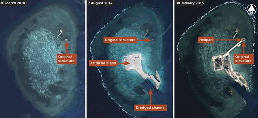
The National Geospatial-Intelligence Agency is using technology akin to facial recognition to track and predict China's strategy for militarizing a region known as Mischief Reef.

Technology akin to facial recognition is helping U.S. spies predict where the next mysterious man-made isle will appear in the South China Sea.
For months, the Chinese have been "dredging up sand and they are building these islands" to mark their territory and, "over time, our ability to kind of human cognitively process all of that coverage is just going to be overwhelmed," National Geospatial-Intelligence Agency Director Robert Cardillo said during a recent interview.
The intelligence community has too much satellite imagery of the area to sort through. Information overload is becoming a concern.
So, the agency is using "broad-based change detection" tools to calculate where in the water the Chinese might next break ground, so to speak.
"That’s a very tough place to monitor," Cardillo said. "Very big, very broad, very noisy. We have had some success with modeling to help us cue when and where something has changed."
By erecting land, China is trying to lay claim to a resource-rich archipelago called the Spratly Islands whose ownership is contested among at least three other countries, including the Philippines. The man-made structures reportedly are large enough to dock warships and support a runway for spy planes.
Cardillo said: "I don’t know what the Chinese plan is for their next dozen islands. The possibilities are big as to where they could do that. I’d rather have the computer tell me that there’s enough change in this part of the ocean, that you should go check that out."
(Related: China’s Island-Building Spree Is About More Than Just Military Might)
On Thursday, after The New York Times published new commercial images of island-making, Defense Secretary Ash Carter also declined to speculate on China's strategy for militarizing the zone, known as Mischief Reef.
Carter reiterated the U.S. arms-length stance on the situation, saying "the militarization of these territorial disputes by anybody is something that we oppose and is something that can lead to dangerous incidents."