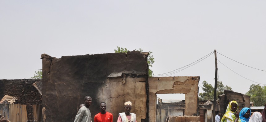
People stand outside burnt houses following an attack by militants in Gambaru, Nigeria, on May 11, 2014. Jossy Ola/AP
Satellite Imagery Is Revolutionizing the Way We Respond to Wars
A 60-year-old technology is being reinvented to illuminate the world's blind spots and even predict and prevent conflicts and humanitarian disasters.
On January 8—just hours after the attack on Charlie Hebdo in Paris—reports emerged of another massacre by Islamist extremists, this time in northeastern Nigeria. Compared with the carnage in France, the extent of the destruction in Nigeria was transmitted with far less precision. Some sources said the militant group Boko Haram had killed dozens in and around the town of Baga, others said hundreds, and still others thousands. Something awful had happened in Baga, but exactly what wasn't clear. Boko Haram, one local official lamented, had rendered the town of 10,000 "virtually non-existent." With practically no journalists, Nigerian authorities, human-rights monitors, or working Internet and cell-phone networks in Baga to help verify the claims, the town effectively was.
Then, a week later, the scale of the devastation became apparent—via eyewitnesses stationed in space.Amnesty International and Human Rights Watch released striking before-and-after satellite images of Baga and the nearby town of Doro Gowon, purchased from the satellite companies DigitalGlobe and Airbus, which showed thousands of torched buildings. Media outlets seized on the images as corroboration of an otherwise-amorphous atrocity.
"It's the power of the image," the Nigerian human-rights lawyer Clement Nwankwo told the news agency IRIN. "The reason people questioned whether 2,000 people were killed was because that level of brutality was unimaginable. But the images validate that claim.”
It was just the latest demonstration of how a 60-year-old technology is being reinvented to illuminate the world's blind spots, and better investigate—and even predict and prevent—conflicts and humanitarian disasters. And yet there was also something disturbing about relying on satellites 400 miles above the earth's surface to confirm killings committed within a couple of square miles back on earth. Plus, the satellite imagery, for all its value, hasn't changed this basic fact: A month after the assault, it's still not clear how many people died in Baga and Doro Gowon.
* * *
For a sense of how satellite imagery shaped understanding of the attack in Nigeria, consider the comparison from Amnesty below, which is generated by computer software and draws on a technique called false-color image analysis. Healthy vegetation shows up in bright red, helping researchers detect changes in the town of Doro Gowon between January 2 (top) and January 7 (bottom). You can also see how densely packed together Doro Gowon's buildings are.
(Related: The Public Will Soon Be Able to Buy Military-Grade Satellite Images)
Human-rights organizations and private satellite firms have been teaming up since the early 2000s, when, for example, the U.S. Committee for Human Rights in North Korea integrated imagery from the satellite company DigitalGlobe into a report on North Korean prison camps. High-resolution commercial satellite imagery became available for sale to the public in 1999 as governments relaxed their control over satellite imaging following the Cold War, and as part of international "open skies"policies and standards that place minimal restrictions on the ability of satellites from one country to monitor the territory of others.
But the use of geospatial technologies, including satellite imagery, in human-rights work has grown farmore sophisticated and ambitious in recent years. Objectives have expanded from documenting wars and disasters to also anticipating them—to constructing early-warning systems that track troop mobilizations, tank movements, refugee flows, and other worrying signs.
* * *
These trends hold great potential. It's generally cheaper, quicker, and safer to look into possible human-rights violations by turning to satellites than by dispatching an on-the-ground team of investigators (Human Rights Watch was able to obtain its Baga/Doro Gowon images for $350 in a matter of hours, though analyzing the pictures is typically more time-consuming). Satellites can penetrate the world's hardest-to-reach places, even when hostilities are at their fiercest, and they can't be bullied by warring parties. By generating streams of data and broad, detailed views of the same locations over time, they can capture and contextualize the vicissitudes of conflict in previously unimaginable ways.
But some of the purported benefits wobble upon closer inspection. Take the oft-repeated claim that satellite images are the sole source of "objective" information in bitter conflicts. That may be true relative to many other sources, but satellite images are only as valuable as the analysis of them is, and that analysis is subjective and occasionally subject to human error and confirmation bias. In the image above, it was analysts, not satellites, who visually contrasted healthy and unhealthy vegetation, and annotated the resulting picture to call viewers' attention to what they felt was significant. In 2013, after Human Rights Watch released a report on another massacre in Baga by the Nigerian military, the organization and Nigeria's National Space Research and Development Agency relied on satellite images to undercut each other's claims about what did or did not happen in the town. Satellites, too, can be spun differently by different sides in a conflict, particularly when the identity of the perpetrator of a given act of violence is in dispute.
The press, sometimes taking its cue from human-rights organizations and satellite companies, also tends to downplay the significant limitations of satellite imagery and to only highlight its successful deployment, rather than instances in which the technology proves inconclusive or contradicts reports of a human-rights abuse.
The satellite images of Baga, for instance, provided some of the first visual evidence of an attack whose existence up to that point was known primarily through fragments of witness testimony. They provided insights about the number of buildings destroyed and the population density of the towns, which could be combined to arrive at a very rough estimate of the death toll. But critically, the images captured burnt buildings, which—as with other dramatic changes to physical landscapes like the appearance of mass graves, the buildup of military hardware, or the deliberate demolition of homes—are relatively easy for satellites to spot. Instances of, say, small-arms fire by militias or violence carried out under dense cloud cover are essentially impossible to see from space. The satellites over Nigeria offered few clues about who carried out the attacks in Baga and Doro Gowon (in this case, witness testimony clearly pointed to Boko Haram), or where the killings occurred, or what sequence of events led to the deaths. Satellites, in other words, can only track certain kinds of violence, in certain ways.
For these reasons, satellite evidence is often at its best when paired with on-the-ground interviews and surveys. Witness testimony that Doro Gowon residents fled Boko Haram by boat across Lake Chad, for example, lent significance to Amnesty's observation that wooden fishing boats were visible by satellite along the town's shoreline on January 2 but gone by January 7. Researchers can make sense of satellite images by cross-referencing them with witness testimony, and the credibility of witness testimony can be bolstered or challenged with satellite images.
Andrew Herscher, an expert on the architecture of political violence at the University of Michigan, has identified other, less apparent downsides to the use of satellite imagery by human-rights groups."Human rights satellite imaging takes place within a geography of closed territories and open skies—the geography of a world in which repressive regimes can prevent reporting of any human rights abuse and surveillance satellites can report freely on every such abuse," he wrote in a 2014 article for the journal Public Culture. This new geography is one "in which the satellite gaze makes a place for itself by negating the gaze of on-the-ground witnesses." Human-rights organizations, Herscher argues, are now using satellite imagery not just to corroborate eyewitness testimony but also to confirm it, and to substitute for and justify a lack of on-the-ground investigations in closed conflict zones like Boko Haram-held territory in Nigeria or ISIS-held territory in Syria and Iraq. In the case of the attack in Nigeria, the satellite images of Baga and Doro Gowon have now been widely distributed, even as both towns remain largely inaccessible to monitors on the ground.
But Josh Lyons, a satellite-imagery analyst at Human Rights Watch, challenges the contention that organizations like his are forsaking fieldwork for remote-sensing technologies like satellites and drones. He told me that Human Rights Watch has been researching the Baga attack on the ground as well as in space, and that satellite imagery has often strengthened rather than weakened the on-the-ground evidence that the group collects. It has "raised our confidence in testimony that we might not otherwise use, inoculated witness testimony against automatic government dismissal, and amplified the voices of survivors in the media," he told me.
Human-rights groups have long gravitated toward images to "mobilize spectators and shame perpetrators," Herscher points out. But over the past decade or so, these organizations have gone from treating satellite imagery as circumstantial evidence to elevating it as self-evident "proof" of human-rights abuses, and even as "a surveillance system that can deter human rights abuses from occurring." This latter ambition is embodied by George Clooney and John Prendergast's Satellite Sentinel Project, which launched in 2010 and encourages people to monitor conflict in Sudan through satellite imagery under the slogan, "The world is watching because you are watching." Human-rights groups used to release satellite images to spur public action. Today, viewing these images has itself become a form of public action. Herscher believes this phenomenon is breeding passive activism. (A 2013 study by former Satellite Sentinel Project staffers found that while the organization generated considerable publicity for evidence of mass graves in South Kordofan and some of its other important findings, it had failed to force governments to respond to atrocities in Sudan and thereby prevent future atrocities from taking place.)
Lyons claims that cases like the satellite images of Baga, where the pictures in and of themselves are trumpeted as proof of an atrocity, are rare. "For every Baga, we release dozens of other reports where the satellite imagery has played an important role in the research but are not covered by the media with the headline 'Satellite evidence of…'" he told me, adding that satellite data is also used for internal purposes such as approving and planning field missions—an application that rarely receives media coverage.
In fact, Lyons foresees a new vector of human-rights work where such imagery would serve as just one component in three-dimensional software models that fuse information from satellites and social media. For example, a video posted on YouTube purporting to show the Syrian government dropping barrel bombs on a civilian area could be mined for clues about the location, the type of damage inflicted, and even the cloud cover and wind speed at the time, which could then be compared with satellite data and witness testimony to verify the video's claims and identify the precise moment at which the bombs were dropped. That kind of analysis might not arrive with the speed that the Baga satellite images did, but it might tell us a whole lot more about what's going on on the ground.