A map of magnetic fields for navigation THE US AIR FORCE
The Air Force’s Latest GPS Alternative: Earth’s Magnetic Fields
Officials just launched a public challenge to help create the artificial intelligence needed to turn the planet’s magnetic fields into readable maps.

Military leaders have been warning of the fragility of GPS for years and researchers have been working on a variety of solutions, from quantum clocks to inertial navigation. The Air Force is adding a new one, using the earth’s magnetic fields as a secure way to detect location for aircraft and possibly other vehicles.
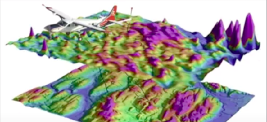
Magnetic fields emanating from the earth’s surface vary in intensity, just like topography, and so-called magnetic anomaly maps of those fields have existed for years. Back in 2017, Aaron Canciani, an assistant professor of electrical engineering at the Air Force Institute of Technology, set out to see if magnetic sensors (magnetometers) affixed to aircraft could measure the intensity of those magnetic fields and, thus, locate the plane based on where it was in relation to those “landmarks.” His paper (and this video) shows how to outfit a Cessna plane with magnetometers in the rear and the front. Forty flight-hours worth of data and a lot of work reducing noise from the readings proved the idea viable.
But swapping magnetic fields for GPS isn’t easy. Unlike a crisp clear signal from space, factors such as the electrical operations of the plane itself — can interfere with a sensor’s ability to detect the strength of the field. This is where artificial intelligence comes in, canceling out the noise from the sensor readings to allow for a better signal and more accuracy.
Researchers in the Air Force’s-MIT Artificial Intelligence Accelerator. community, working with scientists at MIT, continued to work on the problem, publishing their own paper in July. They showed that magnetic field readings can be accurate to ten meters, only slightly inferior to GPS, which is accurate down to three meters. But magnetometer readings are much less easy to jam than GPS signaling. GPS readings rely on a signal sent along a specific wavelength across vast distances. Magnometers just have to read the magnetic environment around the vehicle.
“Because of the size of the earth and the magnetic field… it takes a whole lot to jam a signal coming from the earth, and by a whole lot I mean on the scale of a nuclear blast,” Maj. David "Stitch" Jacobs with the accelerator told Defense One. “Apart from that, it would take a giant scale of a machine to block what’s coming from the earth’s crust. But then you could also cancel it out with machine learning”
The Air Force, working with MIT as part of a new joint accelerator program, has posed a challenge to the open AI community to help with refined AI tools to improve the magnetic field navigation. The challenge closes on August 28.
In something of an unusual step for the military, Air Force leaders are sharing their dataset with the open research community as part of the program. The government generally doesn’t “like to just give up data,” said Michael Kanaan who directs AI and machine learning for the deputy director of Air Force Intelligence. Instead of using the more burdensome contracts that the military typically uses with defense contractors, Jacobs worked with the Air Force general counsel to create a new sharing license for the program that much more closely resembles the sort that academics use when working on open-source data programs. The clickthrough agreement stipulates that the user has to be using the data for research purposes and will report the results back to the AI community as whole. “That was something we created just this year and it's already being executed in several projects, including this one,” Kanaan said.