


NGA's map to put a world of geospatial intell in one place
The digital Map of the World will be the bedrock of the intelligence community’s information sharing.
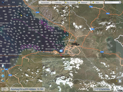
An unclassified image of Haiti shows some of the Map of the World's integrated layers.
By 2018, the National Geospatial-Intelligence Agency envisions a seamless, dynamic Map of the World (MoW) that enables users across the Intelligence Community to visualize and access integrated intelligence content fixed to accurate and authoritative geographic features on Earth.
Through the integration of GEOINT, navigation datasets, imagery and intelligence, this unified, online, geospatial, temporal and relational view of the world will provide a common frame of reference throughout the IC, bringing together multiple sources of information on any object of interest, delivered across multiple security domains and on multiple devices. NGA’s MoW is to serve as the foundation for multi-intelligence integration—the “geospatial bedrock” for all intelligence, information and knowledge—that can be customized by users as needed. It’s a big piece of the IC’s Intelligence Community Information Technology Enterprise plan for cloud-based information sharing across its 17 agencies.
The NGA 2018 Future State Vision, which describes the agency’s strategic direction over the next few years, calls for a MoW that displays “not only NGA-generated data” but also data generated by the Defense Department, the IC and America’s allies. The data will be metadata-tagged and easily accessible, resulting in accurate content and insight that users require on a global basis for situational awareness and mission planning.
“About a year ago, it was really just a thought—what might we be able to do—and as of August [2014] we’ve achieved our first major milestone of getting 12 disparate content views alive, put out there, active and being served out,” said Mike Weingord, director of the Content Management Office at NGA, which is responsible for the creation, maintenance and publishing of MoW. “Those are the initial implementations of the current content views. And they will continue to evolve and get denser and richer with content as we go forward.”
“Our data is no longer static but it’s not as dynamic as we want it to be,” added Chris Lee, deputy director of NGA’s Content Management Office. “With all the new commercial sensors out there and other capabilities, the expectation is going to be that we have a near constant, data real-time Map of the World. It’s going to take some time to achieve that. But, for now, I think within the next two years we’re going to have some real analytic capabilities across the IC with the Map of the World as that underlying foundation.”
Among other data sources, Weingord said that MoW will take advantage of social media and other content feeds. In late July, BAE Systems announced that it had been awarded a five-year, $335 million indefinite delivery requirements contract by NGA supporting MoW in the collection, maintenance and utilization of GEOINT data and products, as well as exploring new sources of data such as commodity data and open-source intelligence.
Tony Baraghimian, vice president and general manager of content and data management at BAE Systems, said MoW is intended to provide all GEOINT and other related sources of data “at the fingertips of the analysts and users so they can better focus their efforts on interpreting the information.” Tradecrafts such as Activity-Based Intelligence as well as automated processing capabilities help analysts find “unknown unknowns,” said Baraghimian, referring to former Defense Secretary Donald Rumsfeld’s term for things “we don’t know we don’t know.”
Craig Brower, NGA account manager for BAE Systems’ Intelligence and Security sector, said his company’s role is to help build the datasets for MoW and to help the agency organize the data into formats that are accessible for IC users. “They’re trying to get out of a lot of the stovepipes and disjointed databases and get things all together in one common place where everyone can come and basically look at one point in time on Earth and go down and see the various layers as they become available, and then do additional analytics on top of that data,” said Brower.