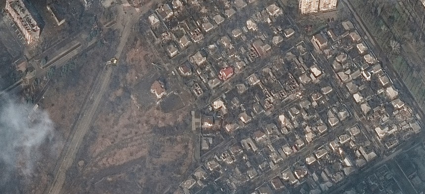
Maxar satellite imagery of destroyed homes and buildings on March 9, 2022. Satellite image (c) 2022 Maxar Technologies


The Ukraine War Is Giving Commercial Space an ‘Internet Moment’
Improvements spurred by Russia’s invasion will help the industry long after the fighting ends.

This article was updated at 9:52 a.m. April 7.
COLORADO SPRINGS, Colo.—Capabilities honed by commercial space companies to document the destruction inflicted by Russia in Ukraine are likely to have long-lasting effects on the industry.
Satellites have brought the world unprecedented glimpses into the brutal war, whether through commercial imagery showing the Russian destruction of a shelter clearly labeled as having kids inside, social-media videos shared via SpaceX’s Starlink satellites, or a photojournalist’s pictures from Mariupol filed through satellite phones. It’s likely these graphic dispatches from the war zone have played at least some role in the global outpouring of support and aid, including the 4 in 10 Americans who said in a March poll that the U.S. should be doing more to help Ukraine.
“We think geospatial intelligence is having its internet moment right now,” said Bill Rozier, the vice president of marketing at BlackSky, which is using artificial intelligence to analyze the satellite imagery it collects over Ukraine.
In addition to giving the public a peek into the crisis in Ukraine, the poignant images have also “opened people’s eyes” to “what can be achieved from space,” said Daniel Jablonsky, CEO of Maxar.
“It wasn’t somebody on the ground, it wasn’t an aircraft flying very low, these were pictures [and] data feeds taken in from space,” he said. “What does that mean for world transparency in the situation that’s going on? What other types of applications might you do with that?”
Commercial companies say they have hastened to improve their capabilities in an effort to provide this window into the war—for example, increasing the resolution of satellite imagery and reducing the time it takes to send intelligence to customers.
“Many of these companies that are working tactically, responsibly in this crisis are doing things like pioneering new processing, exploiting, and dissemination techniques, and they will still have those after the war,” a space industry executive said, speaking on background to discuss the crisis in Ukraine. “Do you get faster? Do you get better? Do you write the software that lets you move that data, filter it better, find the most interesting objects and get them out in minutes not hours? You still have that, and you’ve changed the business.”
It’s not just pictures. HawkEye 360 is tracking radio signals from space to determine where Russia is jamming GPS in Ukraine. The company is doing it out of an “intense desire to help an ally,” CEO John Serafini said, and has expanded its capabilities “by an order of magnitude” since the war began, including improving resolution and making the data more usable by customers.
“There’s certainly a sense of urgency that gets accelerated in extremis, in times of conflict that has led to people working, probably, 18-hour days routinely,” Serafini said in an interview at the Space Foundation’s Space Symposium. “We’ve had to accelerate the development efforts of our satellites, accelerate the development of some of our product capabilities in order to be able to meet the threat in eastern Europe.”
Demand for these capabilities is already going up. When the war erupted, the government more than doubled its purchase of commercial low-Earth orbit imagery over Ukraine from companies like Maxar, BlackSky, and Planet, which was quickly shared with officials in U.S. European Command, NATO, and Ukraine, said David Gauthier, the director of commercial and business operations at the National Geospatial-Intelligence Agency. The agency also boosted its purchase of synthetic aperture radar-based services, which uses radar in space to create 3-D renderings of landscapes of buildings, by more than five times, Gautheir said.
“Months earlier than we had planned, we rolled that into full operation,” he said at a panel discussion hosted by HawkEye 360 on the sidelines of the Space Symposium. “We were patting ourselves on the back a little bit but we still had this feeling in our minds that we needed to get more [geospatial intelligence] directly into the hands of Ukrainians…so my team started to facilitate independent private efforts to directly provide their products and services to Ukrainians.”
Officials also predicted the demand for commercial intelligence and surveillance will continue to skyrocket as capabilities increase and costs come down. The defense and commercial sectors have an insatiable need for data.
“People would wait days for imagery because that was what you did,” a second space industry executive said on background to discuss the situation in Ukraine. “When you show that you don’t have to wait days, that it’s available fairly quickly, the demand signal will be far quicker.”
Blacksky has also tailored its algorithms and machine-learning software to analyze images more quickly and give customers context about what they’re looking at, J.R. Riordan, the company’s chief revenue officer, said in an interview. The company also established a 24/7 operations cell when the conflict began to serve customers more quickly.
Officials likened the use of commercial satellites over Ukraine to the rise of mass production during the World War II industrial revolution or to the first major military use of GPS technology during the first Gulf War. After these wars ended, the developments remained and now mass production and GPS are a routine part of life.
“You’ve got an industry here that’s really at the beginning in terms of deploying fantastic capabilities,” said Todd Harrison, director of Center for Strategic and International Studies’ Aerospace Security Project. “This conflict has brought it to the forefront where people are realizing, ‘Wow, what an advantage these commercial space remote sensing capabilities provide.’ I think that this is changing the way that we fight [and] the way that the world is able to see the fight.”
Jablonsky said Maxar is using data and images collected from space to create virtual reality simulators, so a pilot training in a flight simulator, for example, would be looking at how the world really looks in near-real time, not an artist's rendering or an outdated photo.
“As we build out the world in 3D, you can put the goggles on or you can jump into a cockpit and have a flight simulator or an immersive experience that’s a real-world application,” he said. “If you start to train that way, of this is how the helicopter pilots will see this scenario…it becomes this real-world immersive type of help.”
When companies are not collecting newsworthy images to disseminate to journalists and the public, their main source of revenue is tied to commodities, such as tracking cargo ships hauling goods or counting cars in a shopping center parking lot to set rent prices.
As the Ukraine war makes more people aware that these capabilities exist, imagery and data collected from space could also be used for less lucrative missions, like a county inspector who checks backyard decks for compliance with local regulations. User-friendliness will also help. BlackSky, for example, compares their user interface to shopping on Amazon, saying customers can task satellites to look at a particular area from their home computers.
“The market is wide open,” Riordan said. “There are more people. Once they know what we can do, they will take advantage of this service.”