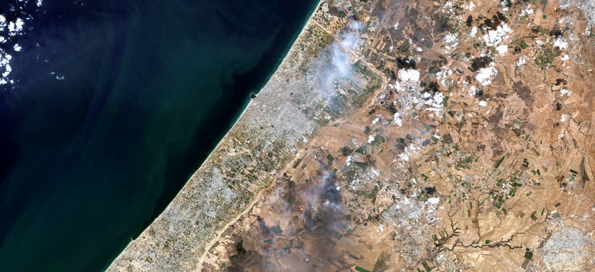
Satellite view of smoke plumes along the Gaza-Israel border, October 7, 2023. Gallo Images / Orbital Horizon / Copernicus Sentinel Data 2023


US says it won’t tell space-imagery companies to stop showing Gaza photos
But the satellite firms may be slowing the release of imagery anyway.

After commercial satellite photos revealed Israeli troops moving in the Gaza Strip, U.S. officials said they won’t require space-imagery companies to change what they release to the public—but some firms appear to be slowing the distribution of photos typically provided to news outlets.
Last year, open-source imagery helped disprove false Russian claims about its invasion of Ukraine. But the escalating war in Israel is raising fresh questions about what happens when satellites train their cameras on U.S. allies at war.
Companies like Planet Labs and Maxar Technologies have allowed news agencies to track Israel’s ground assault in Gaza and detail the destruction from airstrikes the Israeli military launched in response to Hamas’ terrorist attacks on Oct. 7.
U.S. regulation of space imagery is overseen by the National Oceanic and Atmospheric Administration, which is “not considering additional restrictions and constantly monitors licensees for compliance with the conditions of their licenses,” said NOAA spokesperson Scott Smullen.
But reports have surfaced that since Israel’s ground invasion of Gaza, Planet has restricted and obscured parts of images of Gaza for users and delayed the release of certain images.
A Planet spokesperson said the company continues to make images of Gaza available to clients, citing data recently featured in Washington Post and NBC articles.
“Enabling transparency and promoting responsible data practices throughout the ongoing conflict is a core tenet of Planet’s mission, and we will continue this important work,” a spokesperson said.
NOAA, which gives licenses to companies to operate private remote-sensing satellites, already puts some restrictions on what images satellites can take, such as photos of sensitive military sites. These licenses allow the U.S. government to order a commercial company to close its satellite’s eye over a certain area or during a certain period of time. But this "shutter control” has never yet been used—and it only applies to U.S. companies.
And U.S. law has for decades limited the release of high-resolution satellite imagery of Israel. Since 1997, the Kyl-Bingaman Amendment has forbidden U.S. companies to publish photos more detailed than those available from foreign sources. This effectively restricted imagery to 2-meter resolution until 2020, when NOAA began to permit the distribution of 40-centimeter imagery.
"All NOAA Commercial Remote Sensing Regulatory Affairs issued licenses have a standard condition that restricts licensees from disseminating unenhanced data, or processed data or products, derived from the licensed system, of the State of Israel at a resolution finer than the most recent resolution specified in the Federal Register as being available from commercial sources,” said NOAA’s Smullen.
Meanwhile, Maxar releases satellite images of Ukraine at 30-cm resolution, clear enough to make out small features on the ground.
But the Israel-Hamas war is different from the conflict in Ukraine “because the imagery has the potential to reveal things our ally may not want the public to see, such as troop movements and the specific location of strikes,” said Todd Harrison, a longtime defense analyst who is the managing director of Metrea Strategic Insights.
Instead of invoking shutter control, Harrison said that the government has previously used contracts to buy up imagery they want to remain hidden. But “that approach is more complicated now because there are so many different companies in the market with a greater variety of imagery products available, making it complicated and logistically difficult to just buy up everything on the market,” he said.
The “soft touch” way to handle this is for the government to ask companies to use some discretion—the motivation being companies can avoid angering the U.S. government, a large and lucrative customer, Harrison said.
However, Maxar officials say the company is the “primary decision maker” about whether and when it will release an image to the public, said Maxar Intelligence spokesperson Brian Wagner. Wagner added that the company abides by U.S. commercial license regulations.
Maxar releases occasional imagery to the public through its “news bureau,” which is “focused on providing imagery to increase global transparency and combat the spread of disinformation. We provide imagery to news outlets regardless of their political viewpoints for the purpose of documenting history, with the understanding that supplying Maxar imagery to an outlet does not mean endorsing its views,” Wagner said.
He said the imagery shared with Maxar’s government customers is intended to support U.S. and allies’ national-security missions.
Planet also gives away some photos to news outlets. The company said that its imagery and services can serve as a “powerful tool” for increasing peace and security.
“We continually monitor the provision of our service to reduce the potential for misuse and abuse through internal controls and processes, which includes discussions amongst our leadership team and review by our Ethics Committee. Planet is committed to enabling transparency and promoting responsible data practices throughout the ongoing conflict,” a spokesperson said.
Harrison said these and other sources of aerial imagery give an unprecedented real time understanding of battlefield events. He added that the expansion of commercial space remote sensing is making war more transparent for the world and is changing how military operations are conducted.
“Overall, I think this puts rogue or authoritarian regimes at a relative disadvantage because they stand to lose much more from increased transparency. But it poses many challenges for the United States and its allies and partners as well,” he said.